Coordinates
Advertisement
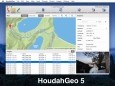
HoudahGeo v.5.2.2
HoudahGeo is a photo geocoding and geotagging tool. Use HoudahGeo to attach GPS coordinates and location names to your photos. HoudahGeo writes EXIF and XMP geotags to JPEG and RAW image files. Just like a GPS-enabled camera.
Advertisement
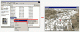
Geodata International v.10.05
Geodata International - World-wide database of countries with georeferenced towns, municipalities, postal codes and administrative units with WGS84 and UTM coordinates and elevations for geocoding, proximity search, navigation, distance calculation.
AllTrans
AllTrans can be used for world wide professional coordinate transformations between international and national coordinate systems with or without geodetic datum change. Transformations between State-Plane-Coordinates (NAD83, NAD27, Transverse Mercator,
Imagination Image Map Editor
Create image maps for your website with this easy-to-use tool from Multimedia Australia. Simply select the image you want to use, choose a shape, then visually draw the image map regions. The image map coordinates can be copied to the clipboard for
ZigZag
Mathematical graphing tool for Windows. Features: Supported graph types: 1. Y(x); 2. X(y); 3. graphs of tables; 4. R(a) - in polar coordinates; 5. X(t) and Y(t) - parametrical equations; You can specify color, style and width
Graphe Easy
Graphe Easy is a feature-rich yet easy-to-use 2d-graph plotting Windows program. It allows to draw many graph types (cartesian, polar, parametric coordinates) and many other graphs such as conics, integrals, inequations or sequences. It also provides a
RapidDXF
RapidDXF reads ASCII (text) or XLS (Microsoft Excel) files of coordinates and creates DXF (version 12) files of points and thier attributes. The DXF files so created are usable in many CAD software. RapidDXF can process several files at a time and lets

5-digit ZIP Code Data - Premium
USA - 5-digit ZIP Code Database, Premium Edition. The database includes ZIP Code, primary city, alternate cities, state, area code, and individually certified latitude & longitude coordinates.
ORTWIN v.13.02
ORTWIN is a program for the inquiry of localities in Germany. It finds postal zip codes, telephone pre selections, coordinates. It performs perimeter searches and distance calculations. It finds landscapes, natural units, snow- and wind load zones.

SEVENPAR (English)
The program produces a set with seven parameters of the sapatial Helmert transformation valid for an specific area, with which then arbitrary coordinates of the area can be transformed from one reference system into another with high accuracy. The
Panorado Flyer
Panorado Flyer is a small, yet very useful tool for linking JPEG image files to the location where the picture was taken, using precise geographical coordinates. It can be lauched from the Windows Explorer's context menu. The coordinates of the place